Before the mid-1920s, #ArchivesOnTheRoad could have cruised the Sunshine Highway in South Dakota in a Fawick Flyer.
- Doris Peterson
- Oct 4, 2024
- 1 min read

Updated: 2 days ago
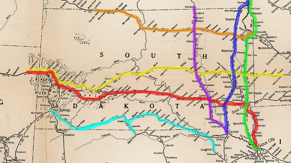
These are some of the named automobile routes in South Dakota in 1920:
Yellowstone Trail – Ortonville, MN to Hettinger, ND – marked on map with orange.
Black and Yellow Trail – Tracy, MN to Sundance, WY – marked on map with yellow.
Custer Battlefield Hiway – Sioux City, IA to Sundance, WY – marked on map with red.
Black Hills Sioux Trail and Black Hills, Rosebud & Omaha Scenic Highway – Hot Springs, SD to Creighton and Valentine, NE – marked on the map with light blue.
King of Trails – Sioux City, IA to Wahpeton, ND – marked on the map with green.
Meridian Highway – Yankton, SD to Fargo, ND – marked on the map with blue.
Sunshine Highway – Yankton, SD to Ellendale, ND – marked on the map with purple.
The map without the color lines is from the Official Automobile Blue Book, 1920. Vol. 10, North Dakota, South Dakota, Kansas, Montana, Wyoming, Colorado, Alberta, Saskatchewan and Manitoba, with Extension Routes into Minnesota, Iowa, Missouri, Utah, Idaho and Washington. Automobile Blue Book Publishing Co., 1920. This book is in the Archives and Special Collections in the Chilson Collection.
The name of the roads are from the Clason’s So. Dakota Green Guide : Showing All the Best Roads : State and City Maps, Auto Road Logs, Railroads, Commercial Index of Towns Giving Hotels, Industries, Altitudes, Population, Etc. Clason Map Co., 1920. This book is in the Archives and Special Collections in the Chilson Collection.
The Fawick Flyer was a car manufactured in Sioux Falls, SD.


Comments